Gothic Line Historical Park
The territory of Badia Tedalda was considered strategically vital by the Germans during the Second World War, becoming the “heart” of the defensive system known as the Gothic Line.
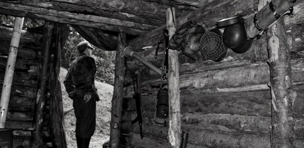
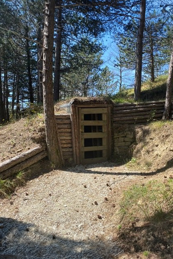
Here, the remains of the fortifications are preserved within a striking and unspoilt natural setting, and can be reached via the trails of the Gothic Line Historical Park.
The Gothic Line Historical Park is a true open-air museum: established in 2011 with the aim of enhancing the material and intangible heritage left to us by these events of the last century, it offers visitors a series of routes connecting the most significant sites, with the purpose of recreating a “journey through memories”.
Also forming part of the Park are two educational trails departing from the village centre of Badia Tedalda, along which visitors can find both original fortification remains and reconstructed positions, together with dedicated explanatory and informational panels.
Furthermore, within the Museo Comunale dell’Alta Valmarecchia Toscana (Municipal Museum of the Upper Tuscan Valmarecchia), a Gothic Line Documentation Centre has been set up: a space equipped with a multimedia installation through which visitors can access a wide range of informational and audiovisual content relating to the Gothic Line and, in particular, to the events in which Badia Tedalda and its inhabitants played a central role.
Guided visits, excursions and educational workshops for schools are available by prior booking.
A living tradition
History has handed down to us an unmistakable product — a treasure chest of local history, culture and tradition, of which we in Pieve Santo Stefano are truly proud.
The Gothic Line Itineraries
IL SASSO DI COCCHIOLA
Starting point: Parco della Memoria (Memory Park) (Badia Tedalda, 698 m a.s.l)
Finishing point: Sasso di Cocchiola (927 m a.s.l.
Length: 3 km
Total ascent: 231 m 231
Return: along the same route
Difficulty: E
Upon reaching the Sasso di Cocchiola, visitors are confronted with the remains of a true complex of fortifications, each of which served a specific purpose.
This site has a distinctive feature: its panoramic position made it well suited for observation and anti-aircraft use, while at the same time it was required to serve as a defensive stronghold against a potential ground attack that might have “broken through” the Passo di Viamaggio. In this regard, it should be noted that in addition to the visible remains, many other positions once existed in the surrounding area that have since been lost: they formed a network that extended, through a series of connecting and contact points, to the Divisional Command at Badia Tedalda.
MONTE DEI FRATI
Starting point: Poggio La Piazzuola (822 m a.s.l.)
Finishing point: Monte dei Frati (1,453 m a.s.l.)
Length: 5 km
Total ascent: 631 m 631
Return: along the same route
Difficulty: E
These areas of the Alpe della Luna, before the arrival of the Gothic Line fortifications, witnessed the presence of several partisan groups and were therefore the scene of partisan actions, Nazi-Fascist round-ups, armed clashes and executions.
In the first part of the route, several vantage points overlook the Val di Bruci, which served as the “logistical base” for the men engaged in the construction of the fortifications on Monte dei Frati: this was, in fact, the furthest point the Germans were able to reach with motorised vehicles.
As the route continues, it becomes clear how the main fortification points were not only strategically positioned, but also maintained a direct “line of sight” with one another.
We are pleased to collaborate with


For further informations
Ass. Pro Loco di Badia Tedalda
Via Alpe Della Luna, 4
452032 – Badia Tedalda (AR)
Primo gruppo di Link
- Titolo del primo link
- Titolo del secondo link
- Titolo del terzo link
Secondo gruppo di Link
- Titolo del primo link
- Titolo del secondo link
- Titolo del terzo link
Terzo gruppo di Link
- Titolo del primo link
- Titolo del secondo link
- Titolo del terzo link
If you would like to take part in our cultural or sporting initiatives, or contribute to the project with your own skills and expertise, please get in touch. We welcome new ideas and collaborations to make our territory even more vibrant and alive. Write to us and become an active part of the change!